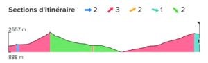
DAY 1 – CHAMONIX-TRIENT
Start of the 1st Stage.
Challenging and picturesque stretch connecting France and Switzerland. It starts in Chamonix, beneath the majestic Mont Blanc, and ascends towards the Col de Balme (2,191 m), a mountain pass that marks the border between the two countries. From the Col, you can enjoy stunning views of the Swiss glaciers and peaks, with the Trient Glacier as the protagonist. The descent towards the small town of Trient runs through green valleys and rocky paths, offering a contrast between the snowy Alpine landscapes and the idyllic Swiss valleys.
Distance: 29km / Slope: 2339+2105-
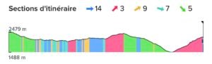
DAY 2- TRIENT-CABANE DE MILE
Start of the 2nd Stage.
A stretch that combines the tranquillity of the Swiss valleys with the majesty of the Alpine landscapes. Starting from Trient, the route gently ascends through the Val d'Arpette, a narrow valley surrounded by impressive mountains. After reaching the Col de la Forclaz, it descends towards the picturesque village of Champex-Lac, with its beautiful Alpine lake.
From Champex, the climb intensifies towards high pastures and more technical trails leading up to the Cabane de Mille (2,473 m). This hut offers spectacular views of the surrounding peaks and the Val de Bagnes, providing a sense of isolation and connection with alpine nature.
Distance: 29.7km / Slope: 3042+1974-
DAY 3: – CABANE DE MILE-CABANE DE LOUVIE
Start of the 3rd Stage.
Starting from the Cabane de Mille (2,473 m), the trail gently ascends through alpine pastures, with panoramic views of the Val de Bagnes and the surrounding peaks. As you continue, you head towards the Col de Mille (2,473 m), which offers stunning views of Mont Blanc and the Grand Combin.
From there, you begin a technical descent into the valley, passing through rocky slopes and uneven terrain, until you reach the vicinity of Fionnay. The trail then climbs steeply again towards the Cabane de Louvie (2,250 m), located next to the beautiful Lac de Louvie. This refuge offers extraordinary views of the Grand Combin and other major peaks, surrounded by a wild and remote environment ideal for observing local wildlife, such as mountain goats.
Distance: 22.5 km /Gradient: 1536+1801-
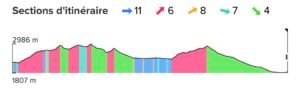
DAY 4: – CABANE DE LOUVIE-AROLLA
Start of the 4th stage
One of the most challenging and spectacular stages of the Haute Route, with a demanding alpine route that crosses technical terrain and glaciers. Starting from the Cabane de Louvie (2,250 m), the path climbs towards the Col de Louvie before facing one of the most difficult parts: the ascent of the Col de Prafleuri (2,987 m).
After the Col, a technical and rocky descent begins towards the Val de Nendaz, followed by a gradual ascent to the Col de Riedmatten or the Pas de Chèvres, where the famous metal stairs are located. From the pass, you descend towards Arolla, a charming alpine village surrounded by glaciers and imposing mountains. This section stands out for its isolation, breathtaking views and the feeling of being completely immersed in the high mountains.
Distance: 32.6 km / Slope: 2022+2410-
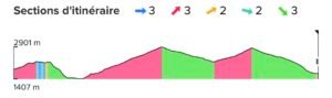
DAY 5: – AROLLA-ZINAL
Start of the 5th Stage
A long and spectacular stretch of the Haute Route, which passes through some of the most impressive landscapes in the Swiss Alps. Starting from Arolla (2,000 m), the path climbs towards the Col de Torrent (2,919 m).
After crossing the Col, a steep descent begins towards the Lac de Moiry, a beautiful turquoise glacial lake, where you can take a break at the nearby refuge. The landscape here is a combination of glaciers, alpine pastures and views of the high peaks.
From the lake, the route continues towards the Val de Zinal, climbing slightly before beginning the final descent towards the village of Zinal (1,675 m).
Distance: 28.8 km / Slope: 2575m+2745-
DAY 6: – ZINAL-SANKT NIKLAUS
Start of the 6th Stage
It starts in Zinal (1,675 m), ascending along alpine paths towards the Col de la Forcletta (2,874 m), a high pass that marks the transition between the Val d'Anniviers and the Turtmanntal.
After the pass, you descend into the Turtmann Valley, a more remote and peaceful landscape with alpine pastures and small traditional villages. The route then climbs again, this time towards the Augstbord Pass (2,894 m), another major pass offering wide panoramas of the Valais Alps.
The final descent to Sankt Niklaus (1,120 m) is steep, crossing alpine forests and green meadows. Located in the Mattertal, Sankt Niklaus is a picturesque Swiss village that serves as the gateway to the valley leading to Zermatt, making it a key stopover before the final stretch of the Haute Route.
Distance: 34.7 km / Slope: 2378m+2931-
DAY 7: – SANKT NIKLAUS -ZERMATT
Start of the LAST STAGE of the tour
A spectacular conclusion to this Alpine crossing. Starting from Sankt Niklaus* (1,120 m), the trail ascends towards the Europaweg, one of the most spectacular trails in Switzerland. This section runs along the top of the valley, offering incredible panoramas of the highest peaks of the Swiss Alps, such as the Dom and the Weisshorn. During the hike, you cross the famous Charles Kuonen Suspension Bridge, the longest pedestrian suspension bridge in the world, which offers a dizzying experience and a unique view of the valley.
After following the Europaweg, the stage slowly descends towards Zermatt (1,608 m), the famous town at the foot of the Matterhorn.
Distance: 32.6 km / Slope: 2844m+2359-
Car-free Zermatt is an iconic destination in the Alps, surrounded by glaciers and towering mountains, making it the perfect end to your Haute Route journey.
Note: The planned itinerary may vary slightly depending on weather conditions and terrain.
![]() Starting point: 8:00 a.m. at the Aiguille du Midi cable car on the first day of the tour.
Starting point: 8:00 a.m. at the Aiguille du Midi cable car on the first day of the tour.
![]() End of tour: 5:00 PM Zermatt train station
End of tour: 5:00 PM Zermatt train station
![]() Nearest airport to Chamonix: GENEVA
Nearest airport to Chamonix: GENEVA
![]() Transfer to Chamonix by scheduled bus:
Transfer to Chamonix by scheduled bus:
![]() Station of Chamonix train
Station of Chamonix train
![]() Optional accommodation in Les Houches before and after the tour: ROCKYPOP Les Houches
Optional accommodation in Les Houches before and after the tour: ROCKYPOP Les Houches