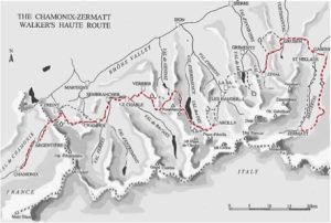
- Day 1: Champex to Cabane de Chanrion
You'll start in Champex and hike to the village of Fionnay. From there, you'll follow the trail up to the Chanrion hut, which sits at an altitude of 2,462 meters. The hike will take approximately 6 hours.
- Day 2: Cabane de Chanrion to Cabane de Prafleuri
From the Chanrion Hut, you'll continue toward the Mont Avril Glacier and ascend to the Otemma Pass. You'll then hike across the Prafleuri Glacier to reach the Prafleuri Hut, located at an altitude of 2,625 meters. The hike will take approximately 6-7 hours.
- Day 3: Prafleuri Cabin to Arolla
From the Prafleuri hut, you'll hike over the Forclaz Pass to reach the Dix hut. From there, you'll follow the trail down to the village of Arolla, where you'll spend the night. The hike will take approximately 5 hours.
- Day 4: Arolla to Cabane des Vignettes
From Arolla, you'll hike to the La Gouille refuge and continue to the Arolla Glacier. After crossing the glacier, you'll reach the Special Pass and descend toward the Les Haudères hut. From there, you'll ascend the Arolla Glacier and reach the Vignettes hut, located at an altitude of 3,157 meters. The hike will take approximately 6-7 hours.
- Day 5: Cabane des Vignettes to Cabane de Bertol
From the Vignettes hut, you'll ascend to the Evêque Pass and hike across the Mont Miné glacier to reach the Bertol hut, located at an altitude of 3,311 meters. The hike will take approximately six hours.
- Day 6: Bertol Cabin to Schönbielhütte
From the Bertol hut, you'll hike across the Mont Durand glacier to reach the Tête Blanche col. After descending the Stockji glacier, you'll reach the Schönbielhütte hut, located at an altitude of 2,694 meters. The hike will take approximately 6-7 hours.
- Day 7: Schönbielhütte to Zermatt
From the Schönbielhütte cabin, you'll hike to the village of Zmutt and follow the trail up to the Augstbord Pass. From there, you'll walk along the Europe Panorama Trail to Zermatt, where it ends.